Personal Workbench — An Agent-Operated Knowledge Pipeline
2026 · ongoing
Designer & Sole Developer
A personal operating system that turns the day's incoming clutter — links, slide decks, PDFs, stray to-dos — into searchable, actionable structured assets. It runs on Claude Code and stores everything as plain markdown under git, with no database, no service, and no account. Anything dropped into a Discord channel from a phone is fetched, extracted, classified, templated, and filed — arriving as a pull request for review rather than a silent write.
Built on one governing constraint: the system's daily writer is an agent, not a person — so every rule in the contributing guide must carry an automated check, and one check verifies that property itself (7 rules, 6 check scripts, one command to run them all)
Chose markdown + git over Notion or SQLite specifically so every agent write produces a reviewable diff — the precondition for the human merge gate, and the reason full-text search is just grep
Replaced the official Discord channels plugin with a self-built zero-dependency Python REST polling bridge after diagnosing that WebSocket — and only WebSocket — was blocked on the host network; diagnosis used the gateway HELLO frame as the criterion, since "the socket connected" yields false positives
Hardened into a always-on service — launchd auto-restart, a file lock so two pollers cannot overwrite each other's watermark, and loud failure on permission denial, because "looks like it is running but is not" is the most expensive failure mode
Governance patterns distilled from two earlier real projects rather than designed from scratch, converged into a skeleton one person can maintain
Three intake channels, one digest step, four kinds of output — and a single pull request as the only way in. No path bypasses human review.
Desk Pet — A Trilingual Site Companion in One Component
2026 · ongoing
Designer & Developer
A floating water-drop character on this site that walks, flies, dances, greets arriving visitors, and answers questions. What began as a static avatar grew into a five-layer system inside a single Astro component — a hand-drawn SVG body with no bitmap assets, a CSS state machine, a JavaScript scheduler with mutual-exclusion guards, a trilingual copy pool, and an on-demand Q&A backend. It is the most personal detail on an otherwise research-toned site.
Entirely vector: the character is one hand-written 64×64 SVG — body, glassy ears, and every costume are paths and gradients, with no image files anywhere
Costumes follow one uniform pattern — always present at opacity 0, revealed by a state class — so they cross-fade smoothly and never cause layout shift; adding a new outfit means following the pattern, not inventing one
Expressions swap whole shapes instead of stretching one: each eye and mouth variant is its own path, so a sleepy squint and a happy arc can each be tuned independently
Every decorative behaviour is scheduled through explicit mutual-exclusion guards, so the pet cannot start dancing mid-yawn — a constraint that has to be extended deliberately with each new action
Flies to the navigation bar to point visitors at sections they might otherwise miss, with playful copy written per language rather than translated, since several lines are culture-specific jokes
Fully honours prefers-reduced-motion on both the JavaScript and CSS sides, and the backend is woken only on an explicit click — never from the idle loop
Five layers in one component, coldest at the bottom — the visual layer is always on, the backend wakes only on a click.
SVG animationCSS state machinesAstroTailwind CSSi18n (en/zh/fr)Accessibility (prefers-reduced-motion)Cloudflare Pages
知几 · MurSense — Conversational AI for Bridge Health Monitoring
2026 · ongoing
Solo Founder & Full-Stack Developer
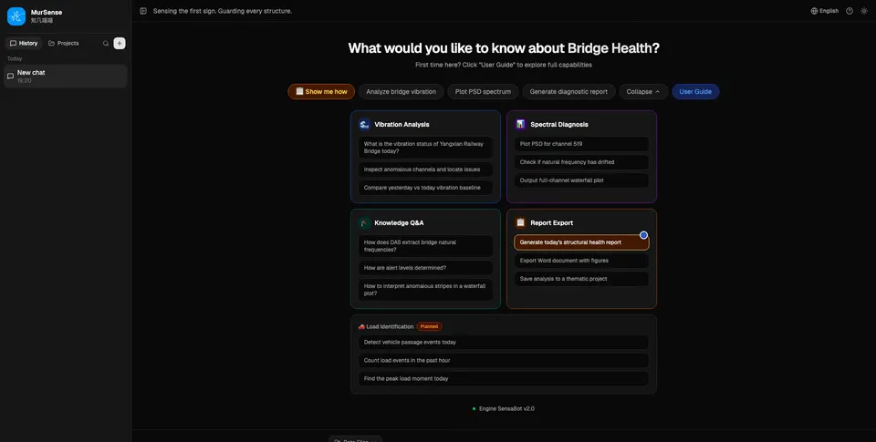
A conversational AI agent that turns kilometer-scale fiber-optic (DAS) sensing data into plain-language bridge-health answers — a verdict, the reasoning, and an exportable engineering report, in one question. Solo-built end-to-end, trilingual (Chinese/English/French) from day one.
Compresses the full workflow — raw DAS waveform → spectral analysis → modal frequency estimation → health verdict — into a single conversational exchange, computed in seconds to under two minutes
Produces standard engineering output: PSD spectra, modal frequencies, strain RMS, five-level color-coded alerts, and a one-click archivable Word report
Built solo end-to-end: frontend, backend, AI agent design, and the underlying DAS signal-processing domain logic
Trilingual product (Chinese/English/French), switchable in one click — the same i18n design principle later applied to this personal site
The landing screen — one question box, four capability groups, no dashboard to learn first
DAS (Distributed Acoustic Sensing)AI Agent DesignReactFull-stack DevelopmentStructural Health Monitoringi18next
GeoWhisper / DASGPT — AI Assistant for a Bridge Monitoring Dashboard
2026 · ongoing
DAS Algorithm Expert & Product Lead, Team of 4 — DFW 2026 AI & Startup Competition (Finalist)
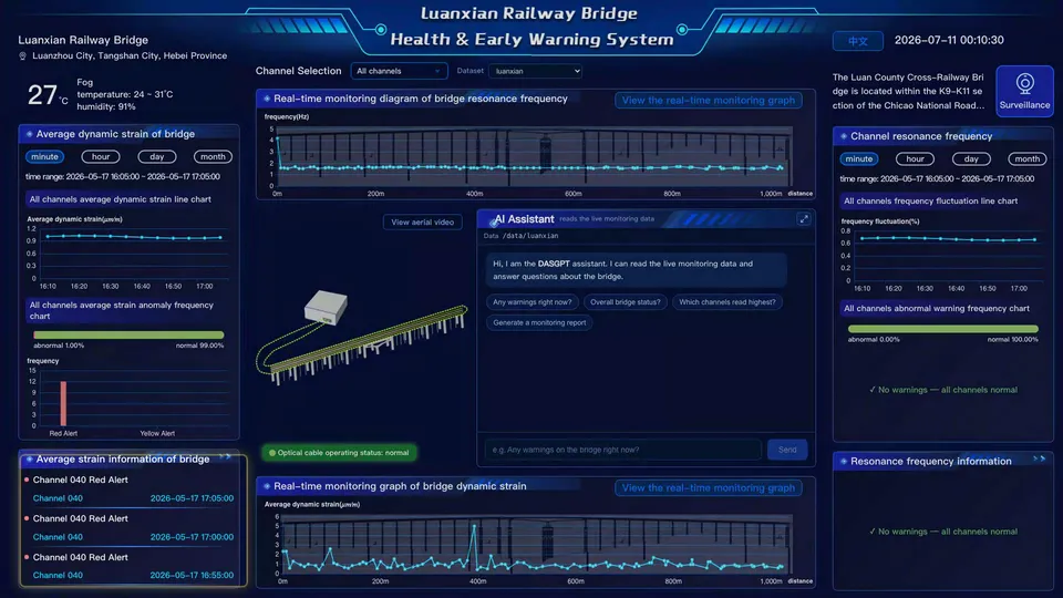
A 4-person team competition entry for the DFW 2026 AI & Startup Competition, now a finalist. The team's existing bridge structural-health monitoring dashboard needed a way to answer plain-language questions about live DAS data — I proposed and led embedding a conversational AI assistant directly into that dashboard as one integrated module.
Advanced to the finals of the DFW 2026 AI & Startup Competition
Proposed and led the integration of a conversational AI assistant into the team's pre-existing bridge-monitoring dashboard, rather than building a standalone app
Distinct in scope from MurSense: here the AI assistant is one embedded window within a larger dashboard product built by a 4-person team, not an independent full-stack product built solo
The AI assistant as one panel inside the existing dashboard, not a separate app
DAS (Distributed Acoustic Sensing)AI Agent IntegrationTeam CollaborationStructural Health MonitoringProduct Strategy
Urban Mobile Source Tracking and Edge Detection Device Development
2026 · ongoing
Led development
Developing innovative system for tracking urban mobile sources using DAS technology and edge computing. Focuses on real-time signal interpretation and anomaly detection in smart city context. Currently in implementation phase with Southern University of Science and Technology.
Integrated edge computing framework with DAS interrogator for real-time processing
Developed signal processing algorithms for mobile source identification and tracking
Collaboration with Southern University of Science and Technology — second collaborative project (ongoing)
Dam Structural Health Monitoring Using Distributed Acoustic Sensing
2026
Co-investigator (Co-first author)
Comprehensive dam safety monitoring project using DAS technology. Comparative analysis of fiber-optic sensing versus traditional seismometers. Paper submitted as co-first author to peer-reviewed journal.
Deployed DAS system for continuous structural health monitoring of an earthfill dam
Conducted comparative analysis: DAS vs traditional seismometers for dam monitoring
Co-first author on paper submitted to Earthquake Science (under review)
Demonstrated structural reinforcement detection after curtain grouting intervention
DASStructural health monitoringFiber-optic sensingComparative analysisDam engineering
AI-Driven Seismic Monitoring and Event Localization System
2024-2025
Algorithm Lead & System Integration Lead
Comprehensive seismic monitoring system combining AI event detection with EarthX seismic localization technology. Integrated end-to-end pipeline for automatic earthquake detection, location estimation, and mechanism analysis. Deployed in Feidong region for continuous one-year monitoring with 1000+ event detections.
Led algorithm optimization for EarthX seismic localization system: STA/LTA triggering, PhaseNet auto-picking, real-time localization, and focal mechanism solutions
Deployed MobileNet-based seismic event detection on datasets ranging from 1.8K to 19K samples, significantly improving precision and recall
Deployed continuous monitoring system in Feidong region for one year, processing 1000+ seismic events with automated detection and localization
Integrated end-to-end pipeline: real-time signal processing → AI detection → automatic location → focal mechanism analysis
Standardized signal preprocessing pipelines, data slicing, and cross-line model evaluation for production deployment
Developed a multimodal neural network combining vibration, audio (via LSTM), and visual data (via YOLO) for vehicle classification and weight prediction.
Improved estimation accuracy with signal alignment and feature fusion layers
Urban Infrastructure Safety Monitoring System — Verification and Product Development
2024
Project Director / Led development
Led comprehensive development and verification of city-scale infrastructure safety monitoring system across six infrastructure categories: bridges, tunnels, highways, dams, slopes, and airports. Served as overall project director for government validation phase covering 16+ verification projects with complete end-to-end responsibility from deployment planning to product roadmap development.
Comprehensive project leadership: equipment deployment planning, project scheduling, data acquisition management across 6 infrastructure categories
Completed 16+ verification projects in the Shenzhen region with full responsibility for data analysis, reporting, and stakeholder communication
Coordinated 7 emergency response deployments including high-profile cases: a high-rise building oscillation incident, a railway infrastructure collapse incident investigation, and real-time structural assessment during typhoon events
Generated 7 granted invention patents directly from verification project outcomes, translating field validation results into IP portfolio
Established product development roadmap based on field validation results, defining technical specifications and deployment strategies for commercial rollout
Managed multi-party stakeholders: government agencies, infrastructure owners, construction teams, and regulatory bodies
Traffic Monitoring Solution — Integrated Multi-Scenario System
2022-2025
Algorithm Lead & System Integration Lead
Comprehensive multi-year traffic monitoring and analysis solution providing complete end-to-end system for urban traffic intelligence. Developed from initial research phase through production deployment with real customer projects.
Led evolution from research prototype to production system: AI-driven traffic signal interpretation from ground vibration data → deep learning pipelines for anomaly detection → commercial deployment
Developed multi-scenario capabilities: vehicle flow monitoring, traffic signal optimization, overweight vehicle detection, road condition assessment, accident detection
Built scalable architecture supporting real-time processing of distributed sensor networks across multiple traffic scenarios
Deployed system across multiple cities with validated customer projects demonstrating operational effectiveness
Airport Runway Safety & Anomaly Recognition System
2024
Led development
Led the development of an airport runway seismic-sensing monitoring system. An array of 121 three-component node seismometers captured continuous ground-vibration data, enabling extraction of aircraft take-off and landing signatures for trajectory tracking, landing-impact quantification, and real-time assessment of runway structural safety.
Built an end-to-end analysis pipeline covering real-time vibration triggering, signal processing, feature extraction, and event classification
Co-developed software that integrates FFT, wavelet analysis, and AI detection modules
Secured three granted invention patents
Deployed at a major hub airport in Guangzhou and a major hub airport in Shenzhen with a 121-node seismometer array
Processed a 792GB large-scale seismic dataset with AirYolo (YOLOv8-based) detection system
Pavement Friction Monitoring via Vibration Sensing
2023
Developer
Developed an innovative method and system to estimate pavement friction coefficients in real time using vibration data generated by moving vehicles.
Designed a multi-module workflow, including vibration acquisition, denoising, and friction inversion calibrated by vehicle behavior and traffic composition
Enabled non-contact, low-cost, and high-efficiency evaluation of pavement roughness under icy or worn surface conditions for traffic safety monitoring
Transportation-AI fusionReal-time algorithm development
AI for Urban Traffic Vibration Signal Interpretation and Analysis
2022-2023
Researcher
Applied deep learning methods to systematic research on urban traffic vibration signal interpretation and analysis. Developed end-to-end pipelines for urban traffic monitoring through ground vibration signal processing and interpretation.
Built deep learning pipelines for anomaly detection and intelligent transportation applications
Developed comprehensive signal processing and interpretation methodologies for urban traffic vibration monitoring
Signal processingUrban traffic vibration analysisAnomaly detection
Entropic Optimal Transport in Seismic Inversion (PhD)
2016-2021
PhD Researcher
Pioneered the application of Sinkhorn divergence in full waveform inversion (FWI), improving misfit convexity and robustness. Developed and published open-source research code advancing geophysical algorithm implementation.
Compared various optimal transport–based objectives (W1, W2, GHK, Sinkhorn) in multiple synthetic and realistic inversion scenarios
Published research implementation code on GitHub, demonstrating advanced Python programming practices and contributing to the open-source scientific computing community
Seismic inversionFWIAdvanced Python programming (PySIT)Mathematical regularization and optimizationOpen-source software development
Kantorovich–Rubinstein (W1) Distance for Mitigating Cycle Skipping (M2 Internship)
2016
Intern
Designed a misfit function using Kantorovich–Rubinstein (W1) distance via SDMM algorithms to replace L2 in FWI.
Demonstrated improved global convergence and reduced local minima sensitivity; awarded top thesis score
Optimal transportWaveform inversionSeismic misfit function
Anisotropy in Micro-seismic Event Localization
2014-2015
Researcher
Evaluated VTI-induced errors in micro-seismic hypocenter localization; integrated P-wave and S-wave birefringence analysis.
Conducted systematic analysis of VTI anisotropy effects on micro-seismic localization accuracy
Integrated P-wave and S-wave birefringence analysis for improved localization
Anisotropic velocity modelsVTI ray tracing
VTI Ray Tracing Research Project
2014
Undergraduate Researcher
Developed a new method for computing group velocity in VTI media and applied shortest-path algorithms in layered models.
Developed novel method for group velocity computation in VTI media
Applied shortest-path algorithms to layered velocity models
Bachelor thesis: Ray Tracing in Vertically Transversely Isotropic Media
VTI wave propagation theoryComputational geometry
3D Geological Modeling (National College Students' Innovation Program)
2012-2013
Student team member
Contributed to 3D modeling of a complex magnetite ore body from geophysical (magnetic/electrical) profiles and drillhole data, funded by National College Students' Innovation and Entrepreneurship Training Program grant 201210616004 and NSFC grant 41274130.
Co-developed a lateral-extension-plus-spatial-interpolation method for 3D modeling of complex ore bodies from 2D geophysical profiles and drillhole data
Co-authored resulting publication in Science and Technology Innovation Herald, 2013
Geological data integrationVisualizationModel interpolation
Ask about Miao
An AI assistant answering questions from Miao's public bio, research, and work.